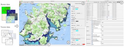
MapMosaic is a novel approach to combine geographical layers based on dynamic visual compositing that enables users to interactively create and manipulate local composites of multiple vector and raster map layers. It takes into account the semantics and attribute values of objects and fields in the compositing process. MapMosaic aims at better supporting GIS users in their tasks such as correlating data from multiple layers and gaining insight from the resulting visualizations.
M.-J. Lobo, E. Pietriga, C. Appert, MapMosaic: Dynamic Layer Compositing for Interactive Geovisualization, International Journal of Geographical Information Science (IJGIS), Volume 31, Number 9, pages 1818-1845, May 2017.
See the project's GitLab page.
If standard screen: ./run.sh -folder <path_to_folder>
If HiDPI screen: ./run.sh -retina -folder <path_to_folder>
MapMosaic only reads .tif and .shp files. The folder must contain at least one Raster file with a .tif extension.